Vertical Exaggeration Calculator
Table of contents
What is a vertical exaggeration?What is the vertical exaggeration formula?How to calculate vertical exaggeration?Welcome to our vertical exaggeration calculator! Let's assume you would like to create a raised-relief map or a three-dimensional drawing/animation. If so, it's essential to consider the vertical exaggeration, as ignoring it may lead to your work being unreadable to some viewers. Don't worry, though - this article will explain precisely how the vertical exaggeration formula works and, most importantly, what are its practical uses.
In the end, you will also learn the meaning of other terms, such as the vertical scale and horizontal scale, and how they connect with the equation mentioned earlier.
Are you rendering a three-dimensional animation? Check out our 3d render calculator to estimate the rendering time!
What is a vertical exaggeration?
Vertical exaggeration is a scale used primarily in the field of geography but also in engineering. It emphasizes certain terrain features or objects by making them larger, ergo increasing their overall visibility. It all sounds overly complicated, so let's bring some visualizations to make things more straightforward.
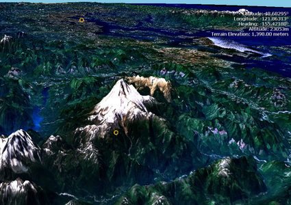
The image above shows a computer-rendered aerial view of Mount Baker, an active stratovolcano in Washington, U.S.A. While you probably wouldn't be able to tell, it has been vertically exaggerated, meaning in the real world, it would appear much flatter.
So, to summarize, vertical exaggeration allows us to increase the readability of raised-relief (three-dimensional) maps and technical drawings by modifying the height of certain areas or objects.
What is the vertical exaggeration formula?
The vertical exaggeration formula is not that complicated:
VE = VS / HS
Where:
VE- Vertical exaggeration, given as a number, e.g. 5× or 20×;VS- Vertical scale, given as a fraction, e.g. 1 : 200 (same as 1 / 200); andHS- Horizontal scale, same as above.
As you see, to calculate the vertical exaggeration used in a map, we first need to know its vertical and horizontal scale. The scale is a fundamental property of every geographical map and can usually be found in the map legend:
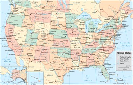
In this case, the legend is positioned just a bit above the bottom right corner:
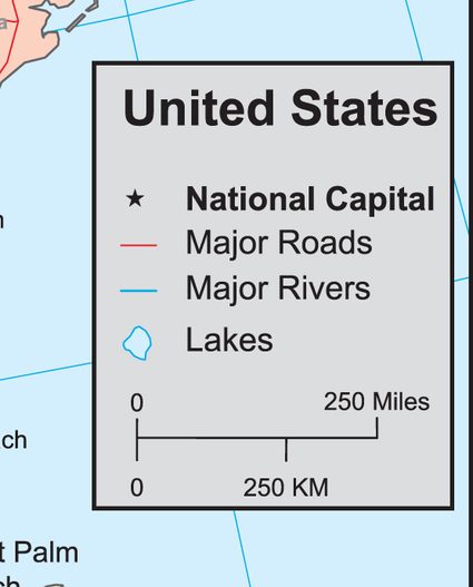
Most maps nowadays tend to use a linear scale, also known as bar or graphic scale. Assuming the distance measured by a ruler from "0" to "250 KM" is 1 centimeter, the representational scale of the map is 1 : 25M (centimeters).
We highly recommend our scale calculator, which you can use to quickly calculate either the horizontal scale or the vertical scale, both of which you can then use in the vertical exaggeration formula. Alternatively, you can tick the checkbox, I want to set the vertical and horizontal scale, it will show the sections accordingly.
How to calculate vertical exaggeration?
The easiest way to calculate vertical exaggeration is by using our free calculator on this page! You only need to supply 2 of the elements from the formula presented above.
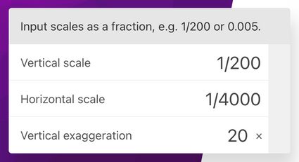
For example, assuming you want to get the vertical exaggeration of a 3D map with a vertical scale of 1 : 200 and a horizontal scale of 1 : 4000:
Here is how you should interpret the result:
- A value higher than 1× indicates vertical exaggeration, e.g., 10× means that vertical measurements are ten times greater than horizontal measurements;
- A value equal to 1× implies no vertical exaggeration; and
- A value lower than 1× means horizontal exaggeration, the opposite of vertical exaggeration.
As you can see, you don't need to be an expert to understand the concept of vertical exaggeration, how to calculate it, and where you can use it. We hope that you found this calculator helpful!